


WASHINGTON TWP Voting District, Wayne County, Iowa
About
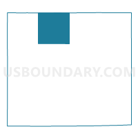
Outline

Summary
| Unique Area Identifier | 583671 |
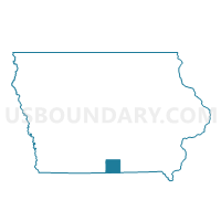
| Name | WASHINGTON TWP Voting District |
| County | Wayne County |
| State | Iowa |
| Area (square miles) | 35.84 |
| Land Area (square miles) | 35.80 |
| Water Area (square miles) | 0.04 |
| % of Land Area | 99.89 |
| % of Water Area | 0.11 |
| Latitude of the Internal Point | 40.84819120 |
| Longtitude of the Internal Point | -93.39399830 |
Maps

Graphs
Select a template below for downloading or customizing gragh for WASHINGTON TWP Voting District, Wayne County, Iowa


Neighbors
Neighoring Voting District (by Name) Neighboring Voting District on the Map
- BENTON TWP Voting District, Lucas County, IA
- BENTON TWP W/O CORYDON Voting District, Wayne County, IA
- CLAY TWP Voting District, Wayne County, IA
- CORYDON TWP W/O CORYDON Voting District, Wayne County, IA
- RICHMAN TWP Voting District, Wayne County, IA
- UNION TWP Voting District, Wayne County, IA
- UNION TWP Voting District, Lucas County, IA
- WARREN TWP Voting District, Lucas County, IA
Top 10 Neighboring County Subdivision (by Population) Neighboring County Subdivision on the Map
- Corydon township, Wayne County, IA (1,776)
- Richman township, Wayne County, IA (619)
- Benton township, Lucas County, IA (366)
- Union township, Lucas County, IA (310)
- Warren township, Lucas County, IA (258)
- Union township, Wayne County, IA (233)
- Washington township, Wayne County, IA (232)
- Benton township, Wayne County, IA (191)
- Clay township, Wayne County, IA (157)
Top 10 Neighboring Unified School District (by Population) Neighboring Unified School District on the Map
- Chariton Community School District, IA (7,354)
- Wayne Community School District, IA (3,522)
- Mormon Trail Community School District, IA (1,636)